- Laman Utama
- Info Korporat

Assalamualaikum Warahmatullahi Wabarakatuh and greetings.
Welcome and thank you for visiting JUPEM Geoportal, the official portal of the Department of Survey and Mapping, Malaysia (JUPEM). It is my hope that this portal will very much facilitate our users in their transactions with JUPEM to obtain up-to-date survey and mapping information.
The creation of JUPEM Geoportal is one of our strategies to introduce and promote JUPEM as an agency under the Ministry of Natural Resources, Environment and Climate Change (nrecc). JUPEM Geoportal interactively provides information on JUPEM such as its organisation structure, activities, services, products and publications. Also available are knowledge corner, photo gallery, video and latest events in JUPEM. The portal will be constantly maintained and updated to ensure only relevant and up-to-date information being published and offered.
I am proud to highlight that in line with our country’s progress towards becoming a developed nation, JUPEM plays an important role as an advisor to the Government pertaining to survey and mapping activities. The entrusted task of demarcating states’ and country’s boundaries are imperative to safeguard the nation’s sovereignty. These activities are also vital for the socio-economic development of the nation.
Since its formation, JUPEM has undertaken various restructuring and modernization programs and projects in order to improve the quality of its services and products. JUPEM has always strived to be compatible with the latest technology development in survey and mapping activities ever since its establishment, from the conventional era up to the current geospatial solutions.
I would like to take this opportunity to welcome any constructive views and opinions to further enhance the quality of our services for the benefit of all.
Again, thank you for visiting this portal.
DIRECTOR GENERAL OF SURVEY AND MAPPING
MALAYSIA
Peringkat Kebangsaan
- Jawatankuasa Pemetaan dan Data Spatial Negara(JPDSN)
- Jawatankuasa Teknikal TC 2 Standard Maklumat Geografi/Geomatik
- Jawatankuasa Kebangsaan Nama-nama Geografi (JKNG)
- Jawatankuasa Penyelidikan Geospatial Kebangsaan
- Jawatankuasa Teknikal Penandaan dan Pengukur Sempadan
- Jawatankuasa Penyelaras MyGDI Kebangsaan (JPMK)
- Jawatankuasa Geospatial Pertahanan
- Jawatankuasa Teknikal Kalendar Islam
- Jawatankuasa Hidrografi Kebangsaan
Peringkat Antarabangsa
- United Nation Global Geospatial Information Management Asia Pacific (UN-GGIM-AP)
- United Nations Group of Expert on Global Geospatial Information Management (UN-GGIM)
- United Nation Group of Experts on Geographical Names (UNGEGN)
- ISO/TC 211 for Geographic Information / Geomatics
- International Steering Committee for Global Mapping (ISCGM)
- International Cartographics Association (ICA)
- International Society for Photogrammetry and Remote Sensing (ISPRS)
- International Association of Geodesy (IAG)
- International Federation of Surveyors (FIG)
Special Public Serve Awards
| NO | YEAR | AWARD |
|---|---|---|
| 1 | 1995 | Files Management |
| 2 | 1992 | Information Technology Management |
| NO | YEAR | AWARD |
|---|---|---|
| 1 | 2003 | Survey Methos for the Proprietary Rights Production of Organized Village Settlement |
| 2 | 2002 | Orthophoto Maps |
| 3 | 2001 | Electronics Maps Development (e-map) |
| 4 | 1998 | Introduction of Measurements For Cluster Land |
| 5 | 1997 | |
| 6 | 1996 | Electronic Site Work Book Development |
| NO | YEAR | AWARD |
|---|---|---|
| 1 | 2023 | |
| 2 | 2020 |
|
| 3 | 2019 |
|
| 4 | 2018 |
|
| 5 | 2017 |
|
| 6 | 2016 |
|
| 7 | 2015 |
|
| 8 | 2004 |
|
| 9 | 2013 |
|
| 10 | 2012 |
|
| 11 | 2011 | Overall Performance Sports Biennial, NRE : 4th in Ministry Level |
| 12 | 2011 |
|
| 13 | 2011 | 5S Practice Certification by MPC |
| 14 | 2011 | Award for Excellence in Achievement Rating 5 Star in Malaysia Government Portals and Websites Assessement 2011 by MDEC |
| 15 | 2011 | Best Human Resource Management Award: 3rd Place for Ministry Level |
| 16 | 2011 | Kumpulan Inovasi dan Kreativiti (KIK) Best Category Technical and Non-Technical Award: 2nd Place for Ministry Level |
| 17 | 2011 | MS ISO 9001 : 2008 (Quality Management System Requirements) |
| 18 | 2010 |
|
| 19 | 2009 |
|
| 20 | 2008 |
|
| 21 | 2008 | ESRI USA Award, Best Achievement Award In GIS |
| 22 | 2005 | Sabah Public Services Quality Award (AQPA) |
| 23 | 2004 | Information Technology Premiere Award Field To Finish |
| 24 | 2003 | Integraph USA Award, Geospatial Achivement Award |
| 25 | 2002 |
|
| 26 | 2001 | The Best Web Site For Public Sector Awards |
| 27 | 2000 | ESRI USA Award, Best Achievement Award In GIS |
|
BIL. |
PERJANJIAN PERSEFAHAMAN/ MEMORANDUM OF UNDERSTANDING (MoU) |
TARIKH PERJANJIAN |
|
1 |
Memorandum of Understanding Between the Government of Malaysia and the Government of The Kingdom of Thailand for The Construction and Maintenance of a Single Barrier in The Area Between Bp20a/12 And Bp 23/104 in Area III (BP16 - BP 27), 2018 |
02 Ogos 2018 |
|
2 |
Kota Kinabalu, Sabah Supplementary Memorandum of Understanding 2003 |
29 Julai 2003 |
|
3 |
Chiang Mai Memorandum of Understanding Concerning The Area Between Bp 13/16 And Bp 15c In Area Vi (Bp Sc - Bp 16) of The Common Land Boundary Between Malaysia and The Kingdom of Thailand 2000 |
28 April 2000 |
|
4 |
Johor Bahru Supplementary Memorandum of Understanding 1999 |
19 Mei 1999 |
|
5 |
Chiang-Mai Memorandum of Understanding 1986 |
29 Mac 1986 |
|
6 |
Kuala Lumpur Memorandum of Understanding 1985 |
02 Julai 1985 |
|
7 |
Bangkok Memorandum of Understanding 1984 |
09 Mei 1984 |
|
8 |
Johor Bahru Memorandum of Understanding 1983 |
25 Mei 1983 |
|
9 |
Bangkok Memorandum of Understanding 1982 |
08 September 1982 |
|
10 |
Kuala Lumpur Memorandum of Understanding 1981 |
11 September 1981 |
|
11 |
Bangkok Memorandum of Understanding 1980 |
26 Jun 1980 |
|
12 |
Kuala Lumpur Memorandum of Understanding 1979 |
07 Julai 1979 |
|
13 |
Bangkok Memorandum of Understanding 1978 |
18 Julai 1978 |
|
14 |
Kuala Lumpur Memorandum of Understanding 1977 |
21 Julai 1977 |
|
15 |
Bangkok Memorandum of Understanding 1976 |
11 Ogos 1976 |
|
16 |
Memorandum of Understanding on the Joint Survey of Common Land Boundary Between Malaysia - Thailand |
08 September 1972 |
|
BIL. |
PERJANJIAN PERSEFAHAMAN/ MEMORANDUM OF UNDERSTANDING (MoU) |
TARIKH PERJANJIAN |
|
1 |
Memorandum of Understanding between The Government of Malaysia and The Government of the Republic of Indonesia on the Demarcation and Survey of the International Boundary between Malaysia (Sabah & Sarawak) and Indonesia (Kalimantan Utara & Kalimantan Barat): Sabah - Area II & III |
21 November 2019 |
|
2 |
Memorandum of Understanding between The Government of Malaysia and The Government of the Republic of Indonesia on the Demarcation and Survey of the International Boundary between Malaysia (Sabah & Sarawak) and Indonesia (Kalimantan Utara & Kalimantan Barat): Sabah- Area II & III and Sarawak - Area III |
10 Oktober 2018 |
|
3 |
Memorandum of Understanding between The Government of Malaysia and The Government of the Republic of Indonesia on the Demarcation and Survey of the International Boundary between Malaysia (Sabah & Sarawak) and Indonesia (Kalimantan Utara & Kalimantan Barat): Sabah - Area II |
07 Jun 2017 |
|
4 |
Memorandum of Understanding between The Government of Malaysia and The Government of the Republic of Indonesia on the Demarcation and Survey of the International Boundary between Malaysia (Sabah & Sarawak) and Indonesia (Kalimantan Utara & Kalimantan Barat): Sarawak - Area III, VII & XIX |
13 April 2006 |
|
5 |
Memorandum of Understanding between The Government of Malaysia and The Government of the Republic of Indonesia on the Demarcation and Survey of the International Boundary between Malaysia (Sabah & Sarawak) and Indonesia (Kalimantan Utara & Kalimantan Barat): Sarawak - Area III & IV |
4 Februari 2005 |
|
6 |
Memorandum of Understanding between The Government of Malaysia and The Government of the Republic of Indonesia on the Demarcation and Survey of the International Boundary between Malaysia (Sabah & Sarawak) and Indonesia (Kalimantan Utara & Kalimantan Barat): Sarawak - Area IV |
31 Oktober 2001 |
|
7 |
Memorandum of Understanding between The Government of Malaysia and The Government of the Republic of Indonesia on the Demarcation and Survey of the International Boundary between Malaysia (Sabah & Sarawak) and Indonesia (Kalimantan Utara & Kalimantan Barat): Sarawak - Area XXI & XXII |
09 November 2000 |
|
8 |
Memorandum of Understanding between The Government of Malaysia and The Government of the Republic of Indonesia on the Demarcation and Survey of the International Boundary between Malaysia (Sabah & Sarawak) and Indonesia (Kalimantan Utara & Kalimantan Barat): Sarawak - Area XX |
26 Februari 2000 |
|
9 |
Memorandum of Understanding between The Government of Malaysia and The Government of the Republic of Indonesia on the Demarcation and Survey of the International Boundary between Malaysia (Sabah & Sarawak) and Indonesia (Kalimantan Utara & Kalimantan Barat): Sarawak - Area XIX |
30 April 1999 |
|
10 |
Memorandum of Understanding between The Government of Malaysia and The Government of the Republic of Indonesia on the Demarcation and Survey of the International Boundary between Malaysia (Sabah & Sarawak) and Indonesia (Kalimantan Utara & Kalimantan Barat): Sarawak - Area XVII & XVIII |
25 April 1998 |
|
11 |
Memorandum of Understanding between The Government of Malaysia and The Government of the Republic of Indonesia on the Demarcation and Survey of the International Boundary between Malaysia (Sabah & Sarawak) and Indonesia (Kalimantan Utara & Kalimantan Barat): Sarawak - Area XVI & XVII |
7 Mac 1997 |
|
12 |
Memorandum of Understanding between The Government of Malaysia and The Government of the Republic of Indonesia on the Demarcation and Survey of the International Boundary between Malaysia (Sabah & Sarawak) and Indonesia (Kalimantan Utara & Kalimantan Barat): Sabah- Area II and Sarawak - Area XV |
6 Januari 1996 |
|
13 |
Memorandum of Understanding between The Government of Malaysia and The Government of the Republic of Indonesia on the Demarcation and Survey of the International Boundary between Malaysia (Sabah & Sarawak) and Indonesia (Kalimantan Utara & Kalimantan Barat): Sabah- Area II and Sarawak - Area XV |
25 Januari 1995 |
|
14 |
Memorandum of Understanding between The Government of Malaysia and The Government of the Republic of Indonesia on the Demarcation and Survey of the International Boundary between Malaysia (Sabah & Sarawak) and Indonesia (Kalimantan Utara & Kalimantan Barat): Sabah- Area II and Sarawak - Area XV |
29 Jun 1994 |
|
15 |
Memorandum of Understanding between The Government of Malaysia and The Government of the Republic of Indonesia on the Demarcation and Survey of the International Boundary between Malaysia (Sabah & Sarawak) and Indonesia (Kalimantan Utara & Kalimantan Barat): Sabah- Area III and Sarawak - Area XV |
20 Oktober 1993 |
|
16 |
Memorandum of Understanding between The Government of Malaysia and The Government of the Republic of Indonesia on the Demarcation and Survey of the International Boundary between Malaysia (Sabah & Sarawak) and Indonesia (Kalimantan Utara & Kalimantan Barat): Sabah- Area I & II and Sarawak - Area VII |
16 September 1992 |
|
17 |
Memorandum of Understanding between The Government of Malaysia and The Government of the Republic of Indonesia on the Demarcation and Survey of the International Boundary between Malaysia (Sabah & Sarawak) and Indonesia (Kalimantan Utara & Kalimantan Barat): Sarawak - Area VII |
28 Februari 1987 |
|
18 |
Memorandum of Understanding between The Government of Malaysia and The Government of the Republic of Indonesia on the Demarcation and Survey of the International Boundary between Malaysia (Sabah & Sarawak) and Indonesia (Kalimantan Utara & Kalimantan Barat): Sarawak - Area V |
30 Mei 1984 |
|
19 |
Memorandum of Understanding between The Government of Malaysia and The Government of the Republic of Indonesia on the Demarcation and Survey of the International Boundary between Malaysia (Sabah & Sarawak) and Indonesia (Kalimantan Utara & Kalimantan Barat): Sarawak - Area IV |
10 Julai 1980 |
|
20 |
Memorandum of Understanding between The Government of Malaysia and The Government of the Republic of Indonesia on the Demarcation and Survey of the International Boundary between Malaysia (Sabah & Sarawak) and Indonesia (Kalimantan Utara & Kalimantan Barat): Sarawak - Area I, II & III |
18 November 1978 |
|
21 |
Memorandum of Understanding between The Government of Malaysia and The Government of the Republic of Indonesia on the Demarcation and Survey of the International Boundary between Malaysia (Sabah & Sarawak) and Indonesia (Kalimantan Utara & Kalimantan Barat): Sabah - Area I & Sarawak - Area I & II |
13 Disember 1976 |
|
22 |
Memorandum of Understanding between The Government of Malaysia and The Government of the Republic of Indonesia on the Demarcation and Survey of the International Boundary between Malaysia (Sabah & Sarawak) and Indonesia (Kalimantan Utara & Kalimantan Barat): Sabah - Area I & Sarawak - Area I & II |
23 Ogos 1976 |
|
23 |
Memorandum of Understanding between The Government of Malaysia and The Government of the Republic of Indonesia on the Demarcation and Survey of the International Boundary between Malaysia (Sabah & Sarawak) and Indonesia (Kalimantan Utara & Kalimantan Barat): For Purpose and Undertaking Survey |
00 Januari 1900 |
BIL. | PERJANJIAN PERSEFAHAMAN/ MEMORANDUM OF UNDERSTANDING (MoU) | TARIKH PERJANJIAN |
1 | Treaty between Malaysia and the Republic of Indonesia relating to the delimitation of the territorial seas of the two countries in the Sulawesi Sea | 8 Jun 2023 |
2 | Treaty between Malaysia and the Republic of Indonesia relating to the delimitation of the territorial seas of the two countries in the Southernmost Part of The Straits of Malacca | 8 Jun 2023 |
3 | Exchange of Letters Malaysia – Brunei | 16 Mac 2009 |
4 | 1995 Agreement between the Government of Malaysia and the Government of the Republic of Singapore to Delimit Precisely the Territorial Waters Boundary in Accordance with the Straits Settlements and Johore Territorial Waters Agreement 1927 | 7 Ogos 1995 |
5 | Memorandum of Understanding between the Government of Malaysia and the Government of the Kingdom of Thailand relating to the delimitation of the Continental Shelves between the two countries | 24 Oktober 1979 |
6 | Treaty between Malaysia and the Kingdom of Thailand relating to the delimitation of the Territorial Seas of the two countries | 24 Oktober 1979 |
7 | Agreement between the Pengarah Pemetaan Negara, Malaysia and the Kepala Jawatan Hidro-Oceanografi, Tentara Nasional Indonesia Angkatan Laut, Relating to the Fundamental Point of the Common Datum | 12 Disember 1974 |
8 | Agreement between the Government of Malaysia, the Government of the Republic of Indonesia and the Government of the Kingdom of Thailand relating to the delimitation of the Continental Shelf Boundaries in the Northern Part of the Straits of Malacca | 21 Disember 1971 |
9 | Memorandum of Understanding between the Director, Royal Thai Survey Department and the Director of National Mapping, Malaysia | 20 Mei 1971 |
10 | Memorandum of Understanding signed between Direktur, Direktorat Hidrografi Angkatan Laut, Republic Inodnesia dan Pengarah Pemetaan Negara Malaysia at Kuala Lumpur | 11 Februari 1971 |
11 | Treaty between Malaysia and the Government of the Republic of Indonesia relating to the delimitation of the Territorial Seas of the two countries in the Straits of Malacca | 17 Mac 1970 |
12 | Agreement between the Government of Malaysia and the Government of the Republic of Indonesia relating to the delimitation of the Continental Shelf between the two countries initialled | 27 Oktober 1969 |
13 | The Sarawak (Definition of Boundaries) Order in Council | 11 September 1958 |
14 | The North Borneo (Definition of Boundaries) Order in Council | 11 September 1958 |
15 | Convention between His Majesty in respect of the United Kingdom and the President of the United States of America regarding the Boundary between the Philippine Archipelago and the state of North Borneo, Anglo-American Treaty | 2 Januari 1930 |
16 | Treaty between Great Britain and Siam | 10 Mac 1909 |
17 | Treaty of Paris between USA and Spain | 10 Disember 1898 |
BIL. | PERJANJIAN PERSEFAHAMAN/ MEMORANDUM OF UNDERSTANDING (MoU) | TARIKH PERJANJIAN |
1 | Perjanjian Sempadan Darat (Kedah - Perlis) | 29 Mei 2023 |
2 | Perjanjian Sempadan Maritim (Kedah - Perlis) | 29 Mei 2023 |
3 | Perjanjian Sempadan Darat (Selangor - Negeri Sembilan) | 4 Julai 2022 |
4 | Perjanjian Sempadan Maritim (Melaka - Negeri Sembilan) | 15 Oktober 2019 |
5 | Perjanjian Sempadan Darat (Melaka - Negeri Sembilan) | 2 Julai 2019 |
6 | Perjanjian Sempadan Darat (Terengganu - Kelantan) | 20 Jun 2019 |
7 | Perjanjian Sempadan Darat (Pahang - Selangor) | 9 Mac 2018 |
8 | Perjanjian Sempadan Darat (Pahang - Negeri Sembilan) | 29 Oktober 2013 |
9 | Perjanjian Sempadan Darat (Pahang - Perak) | 26 Jun 2012 |
10 | Perjanjian Sempadan Darat (Pahang - Terengganu) | 19 Mac 2007 |
11 | Akta A1095 (Selangor - Wilayah Persekutuan Putrajaya) | 1 Februari 2001 |
12 | Akta 1982 (Kedah - Pulau Pinang) | 1982 |
13 | Akta A206 (Selangor - Wilayah Persekutuan Kuala Lumpur) | 1 Februari 1974 |
14 | Gazette (Kedah - Perlis) | 31 Disember 1953 & 28 Januari 1954 |
15 | Agreement between The United Kingdom and Sultan Perak (Perak - Pulau Pinang) | 28 Jun 1939 |
16 | Agreement dan Gazette (Perak - Kedah) | 4 Mac 1912 & 10 Mac 1933 |
17 | Gazette dan surat menyurat antara Residen 1927 - 1929 (Pahang - Selangor) | 11 Jun 1911 |
18 | Gazette (Selangor - Negeri Sembilan) | 5 November 1909 |
19 | Gazette (Perak - Selangor) | 12 April 1901 |
20 | Gazette (Perak - Pulau Pinang) | 6 Julai 1900 & 18 Julai 1902 |
21 | Gazette (Pahang - Kelantan) | 1 Jun 1900 |
22 | Gazette (Perak - Kedah) | 15 Mei 1900 |
23 | Agreement Signed November 29th 1899 (Perak - Kedah, Pahang - Perak, Perak - Kelantan, Kelantan - Pahang & Pahang - Terengganu) | 29 November 1899 |
24 | Award Johore - Malacca, Johore - Johol and Johore - Pahang Boundaries (Pahang - Negeri Sembilan, Johor - Melaka, Johor - Negeri Sembilan & Johor - Pahang) | 18 Februari 1898 |
25 | Jelebu 24 August 1883, surat menyurat antara Gabenor-Bendahara 1884-1885 (Pahang - Sembilan) | 24 Ogos 1883 |
26 | Agreement Between Selangor and Sungai Ujong (Selangor - Negeri Sembilan) | 10 Februari 1878 |
27 | Treaty of friendship 1862 (Johor - Pahang) | 1862 |
28 | Cession of Cape Rachado (Negeri Sembilan - Melaka) | 23 Ogos 1860 |
29 | Treaty Between Britain and Siam 1839 (Kedah - Pulau Pinang) | 1839 |
30 | Rumbowe & Johole 1833 (Negeri Sembilan - Melaka) | 1933 |
31 | Frontier and Boundary Treaties, 1831 (Quedah, 1831) (Kedah - Pulau Pinang) | 1831 |
32 | Treaty with Perak and Salangore 1825 (Perak - Selangor) | 1825 |

YBrs. Sr HAZRI BIN HASSAN
KETUA PENGARAH UKUR DAN PEMETAAN MALAYSIA

YBrs. Sr DR. AHMAD SANUSI BIN CHE COB
TIMBALAN KETUA PENGARAH UKUR DAN PEMETAAN I

YBrs. Sr MUHAMMAD SALIM BIN MOHAMMED ASARI
TIMBALAN KETUA PENGARAH UKUR DAN PEMETAAN II

YBrs. Sr DR. AHMAD SANUSI BIN CHE COB
TIMBALAN KETUA PENGARAH UKUR DAN PEMETAAN I
Emel: @jupem.gov.my
Tel: 03-2617 0890
Fax: 03-2697 0681
| Year | HISTORY OF ESTABLISHMENT | |||
|---|---|---|---|---|
1885 | Johore Survey Department was the first survey department established in Johore State with their first Chief Surveyor, Dato‘ Yahya bin Awaluddin. The first office is located at Sultan Ibrahim Building, Bukit Timbalan, Johor Bahru. | |||
1910 | Johore Survey Department has been placed under the Federated Malay States (FMS) Survey Department. | |||
1982 | Department of Survey and Mapping Johore has been moved to the Bangunan Persekutuan, 7th, 8th and 9th Floor, Block A , Jalan Ayer Molek, Johor Bahru. | |||
Department of Survey and Mapping Johor
Director:
Sr ROSLI BIN MOHAMMED
rosli.mohammed@jupem.gov.my
Level 7,8 & 9, Block A, Wisma Persekutuan,
Jalan Air Molek, 80000 Johor Bahru,
Johor Darul Takzim.
Tel: 07-223 1244 ext 900
Fax: 07-223 8535
District Survey Office
Southern Johor District Survey Office
Tingkat 2, Blok B, Wisma Persekutuan
Jalan Air Molek
80000 JOHOR BAHRU
Tel: 07-221 9934
Fax: 07-223 2190
Northern Johor District Survey Office
Tingkat 2, Wisma Tiam Lock
No.19-4, Jalan Sungai Abong
84000 MUAR
Tel: 06-952 1233
Fax: 06-952 2122
Central Johor District Survey Office
Tingkat 2, Bangunan Gunasama Persekutuan
Jalan Bakau Chondong
83000 BATU PAHAT
Tel: 07-434 1081
Fax: 07-434 0073
Eastern Johor District Survey Office
Tingkat 4, Bangunan Sultan Iskandar
Jalan Lombong
81900 KOTA TINGGI
Tel: 07-883 1307
Fax: 07-882 1244
History and Background
| Year | HISTORY OF ESTABLISHMENT | |||
|---|---|---|---|---|
| 1910 | Department of Survey and Mapping Malaysia established a year after the Treaty of Bangkok in 1909 where Siam ( Thailand ) hands over Kedah and Perlis to the British . Initially housed in two rented stores in Alor Setar . Currently divided into two administrative districts of Kedah in Alor Setar North and South in Kulim Kedah . | |||
| 1913 | JUPEM Kedah Alor Setar moved from Kulim . Located in the residence of Survey on Jalan Bukit Awi . | |||
| 1914 | JUPEM Kedah moved into the building in Jalan Kulim stores in April 1914 . | |||
| 1918 | Measurement in Perlis began under the administration of the Director of Survey , Kedah . Northern Kedah commissioned surveyor conducting the survey for the state of Perlis | |||
| 1947 | District Survey Office South Kedah , Kulim closed because of lack of work and merged with the District Survey Office Central Kedah , Sungai Petani . | |||
| 1956 | Perlis District Survey Office was officially established . Placed in Hospital Jalan Kangar in Perlis under the auspices of the Regional Surveyor. | |||
| 1964 | District Survey Office Perlis , Kangar moved to level 3 of the Federal Government Building on August 15, 1964 after a building in Jalan Hospital was taken over by the Office of Land Supervision Plan Perlis . | |||
| 1968 | JUPEM Kedah moved to its own building now occupied on June 15, 1968 after 54 years the building housed the store . Opening of JUPEM Kedah / Perlis on 18 November 1968 by the Minister of Lands and Mines , Hj . Abdul Rahman bin Yaacob .
District Survey Office , North Kedah , Alor Setar moved from Jalan Kolam Ayer to Building Survey , PKNK on July 8, 1968 |
|||
| 1971 | Kedah District Survey Office Central / South , Sungai Petani move to level 4 , Federal Building , Sungai Petani on June 26, 1971 . | |||
| 1978 | District Survey Office , North Kedah , Alor Setar move to level 4 , Federal Building , Alor Setar on 26 July 1978 . | |||
| 1983 | South Kedah District Survey Office , separated from Kedah District Survey Office Central / South , Sungai Petani and placed on the ground floor of Building Meeting on May 2, 1983 . | |||
| 1995 | JUPEM Perlis created separately from JUPEM Kedah / Perlis on 1 November 1995 . | |||
Department of Survey and Mapping Kedah
Director:
Mr IRWAN KHUSHAINI BIN MOHD JAN
irwan@jupem.gov.my
1187 Jalan Raya, 09000 Kulim,
Kedah Darul Aman.
Tel: 04-490 6181
Fax: 04-490 4223
District Survey Office
Northern Kedah District Survey Office
Tingkat 3, Zon C, Wisma Persekutuan,
Pusat Pentadbiran Kerajaan Persekutuan,
Bandar Mu’adzam Shah,
06550 ANAK BUKIT
Tel: 04-732 3253
Fax: 04-732 0779
Central Kedah District Survey Office
Bangunan Tunku Abdul Malik, Jalan Ibrahim
08000 SUNGAI PETANI
Tel: 04-421 2168
Fax: 04-425 0284
Southern Kedah District Survey Office
1187, Jalan Raya
90000 KULIM
Tel: 04-490 6166 ext. 108
Fax: 04-490 4223
History and Background
| Year | HISTORY OF ESTABLISHMENT | |||
|---|---|---|---|---|
| 1891 | Department of Survey and Mapping Pulau Pinang was establish. At first, it was located at No. 10, Lebuh Downing, Georgetown. | |||
| 1989 | Department of Survey and Mapping Pulau Pinang move to level 39, Kompleks Tun Abdul Razak or well known as KOMTAR, Pulau Pinang until today. | |||
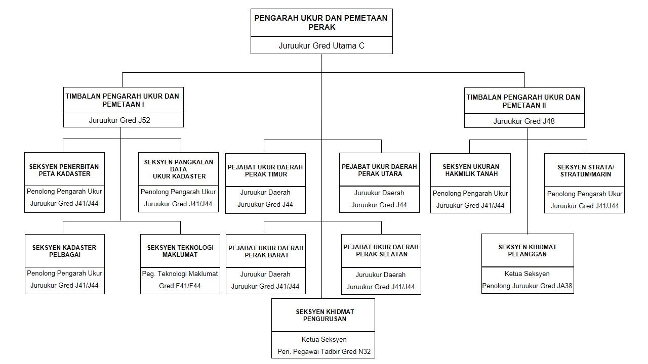
Organisation Chart
Contact Us
Department of Survey and Mapping Pulau Pinang
Director:
Sr ZULKAFLI BIN CHIHAT
zulchihat@jupem.gov.my
Level 39, KOMTAR,
10000 Pulau Pinang.
Tel: 04-261 1773
Fax: 04-263 5884
District Survey Office
Pulau Pinang District Survey Office
Aras 3, Bangunan Mahkamah Majistret
Seberang Perai
Lot 852, Seksyen 4
Jalan Kampung Jawa
12000 BUTTERWORTH
Tel: 04-323 8260
Fax: 04-323 8258
History and Background
| Year | HISTORY OF ESTABLISHMENT | |||
|---|---|---|---|---|
| 1910 | Department of Survey and Mapping Kelantan established on 11 July 1910 in an area known as Buluh Kubu and comprises 6 staff . Then moved to the office of the Carnegie Building , Jalan Doktor until 1931 housed in buildings that are now used as the State Museum now . Establishment of the workforce by the British following the submission of Siam to Kelantan by the British government through the Anglo – Siamese Treaty in 1909 . | |||
| 1926 | In Kelantan , the ownership of land is for primitive and according to traditional practices wither during the reign of Siam until 1910 introduced a more systematic approach to donated alienated land . Works only at the initial stage using a measuring chain and to determine the distance to meet the border without bearing Kelantan Land Enactment 1926 | |||
| 1957 | JUPEM Kelantan building which is now located on Lot 240 Sek.12 Bandar Kota Bharu , Jalan Hospital premises with an area of 1 acre 528.5 fathoms built in 1957 and officiated by YB . Mr Bahaman bin Shamsudin , Minister of Natural Resources, the Federation of Malaya on 18 September 1958 | |||
| 2002 | 2 -storey annexe workforce now cater for the increasing number of current staff of 130 people was completed in 2000 and inaugurated by His Majesty Al Sultan Kelantan on 14 September 2002 at the same 7 Rajab 1423H. | |||
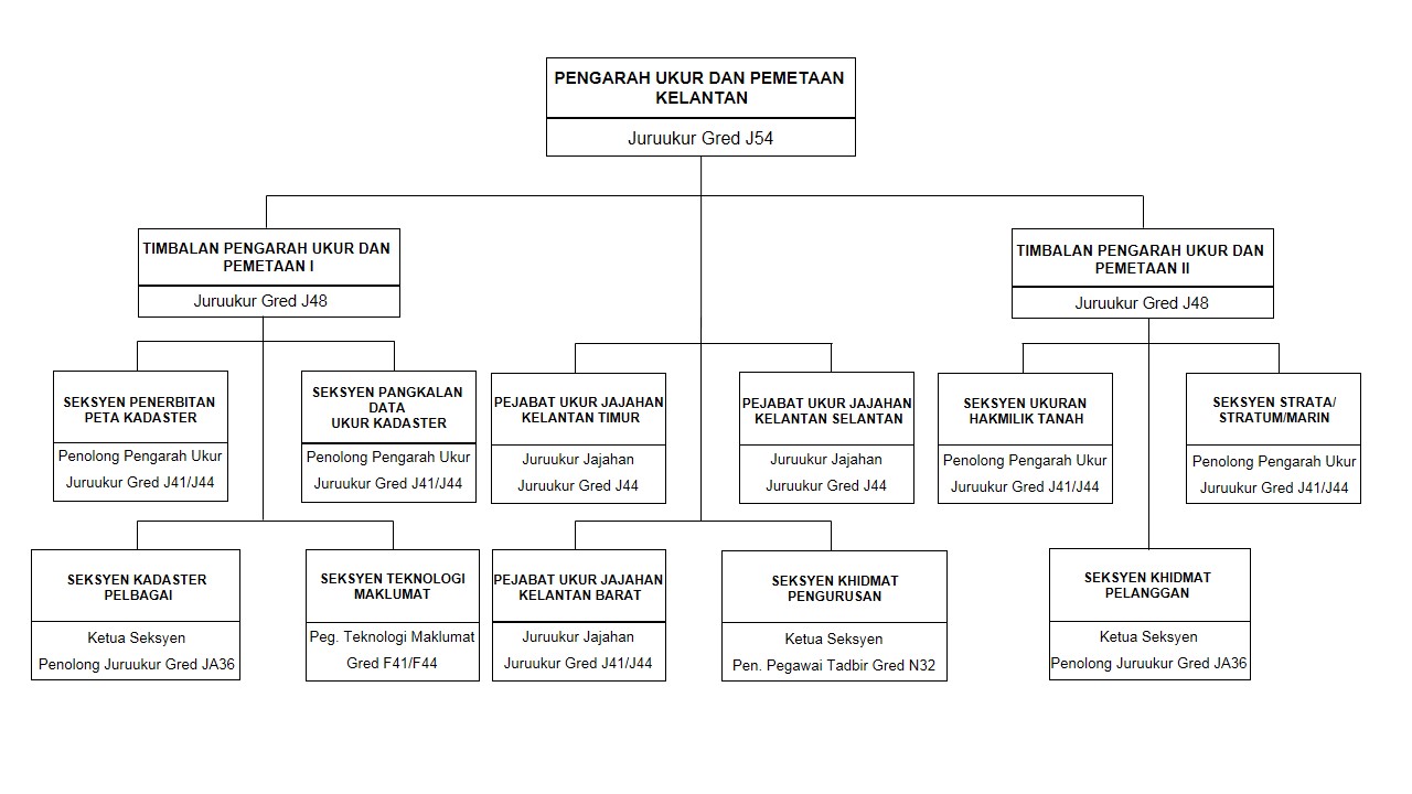
Organisation Chart
Contact Us
Department of Survey and Mapping Kelantan
Director:
Sr Jamil Faisal bin Yusoff
jamilfaisal@jupem.gov.my
Jalan Hospital, 15000 Kota Bahru,
Kelantan Darul Naim.
Tel: 09-748 1588 / 09-748 1470
Fax: 09-744 3923
Colony Survey Office
Eastern Kelantan Colony Survey Office
Tingkat 8, Wisma Ilmu
Jalan Doktor
15000 KOTA BHARU
Tel: 09-748 4577
Fax: 09-747 6235
Southern Kelantan Colony Survey Office
Jalan Pejabat
18500 MACHANG
Tel: 09-975 1206
Fax: 09-975 5854
Western Kelantan Colony Survey Office
Seksyen 1, Bandar Pasir Mas
17000 PASIR MAS
Tel: 09-790 9055
Fax: 09-790 0758
History and Background
| Year | HISTORY OF ESTABLISHMENT | |||
|---|---|---|---|---|
| 1892 | Established in 1892, located in the Strait Patronage of Local Officials . Located in Bandar Kaba , Bandar Hilir Melaka Survey Department officials shared with the Public Works Department . | |||
| 1903 | On 11/30/1903 , Ordinance 81 was used only to allow a surveyor licensed under the Surveyors General to carry out measurements of the registration of the Deed . | |||
| 1920 | On 12/08/1920 , the first named PA2 Certified Plan is approved . | |||
| 1.4.1920 | Department of Survey and Survey Department Singapore Melaka combined and administered under the Public Surveyors ( FMS and SS ) | |||
| 1950 | On 01.01.1950 , the Department of Survey combined Melaka and Negeri Sembilan Negeri Sembilan after the Survey Department was separated from the Department of Survey Selangor . | |||
| 1957 | On 01.01.1957 , the Department of Survey and Survey Department Melaka , Negeri Sembilan was isolated . | |||
| 1967 | On 04/03/1967 , the Building Survey Department moved to Lot 302 , Jalan Taming Sari , KB XXXV , Bandar Melaka and officiated by Tun Haji Abd . Razak bin Dato ‘ Hussin , Deputy Prime Minister . | |||
| 1995 | On 01/01/1995 , JUPEM Malacca stepped into the era of modernization trend computer by using Mini System CALS . | |||
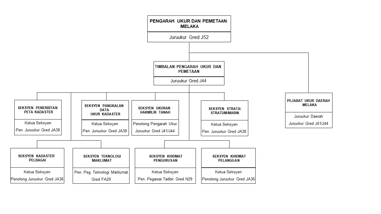
Organisation Chart
Contact Us
Director:
Sr NOOR HELMY BIN NOORDIN
noorhelmy@jupem.gov.my
Jalan Taming Sari, 74500 Melaka,
Melaka.
Tel: 06-282 2844
Fax: 06-284 7319
District Survey Office
Melaka District Survey Office
Aras 15, Menara Persekutuan
Jalan Persekutuan, Hang Tuah Jaya
75450 AYER KEROH
Tel: 06-232 3740
Fax: 06-232 3743
History and Background
| Year | HISTORY OF ESTABLISHMENT | |||
|---|---|---|---|---|
| 1906 | Survey Department Negeri Sembilan began as early as 1906 according to the cadastral map number 1 and number 249 Workbook Affairs . It is still kept in the vaults of the department When the department is under the control of only two departments , namely the Department of Survey Johor and Perak Trigonometry Survey Department which was established in 1885 .. | |||
| 1950 | At the date of 01.01.1950 Department of Survey , Negeri Sembilan and Melaka are listed after the Survey Department Survey Department Negeri Sembilan Selangor separated from the Survey Department . | |||
| 1952 | Survey Department of Negeri Sembilan was formally established this year. The first Survey Director of Negeri Sembilan is Sir Haji Mohd. Yahya Bin Yatim. At that time it was only a small office that is only at the level of the District Land Office Seremban until 1983. | |||
| 1964 | On 10 October 1964, the Kuala Pilah District Survey Office has been established adjacent to the Kuala Pilah Land Office until now. | |||
| 1983 | In October 1983, the Department of Survey and Mapping Malaysia has moved to the 7th floor of Wisma Persekutuan until today . | |||
Organisation Chart
Contact Us
Department of Survey and Mapping Negeri Sembilan
Director:
VACANT
Bangunan Pejabat Persekutuan,
Jalan Dato’ Abdul Kadir, 70000 Seremban,
Negeri Sembilan Darul Khusus.
Tel: 06-762 3839
Fax: 06-762 0158
District Survey Office
Western Negeri Sembilan District Survey Office
Suite 1-3, Arab Malaysian Business Centre
Jalan Pasar
70000 SEREMBAN
Tel: 06-767 7005
Fax: 06-767 7008
Eastern Negeri Sembilan District Survey Office
Kompleks Pejabat Kerajaan Kuala Pilah
72000 KUALA PILAH
Tel: 06-481 1103
Fax: 06-481 0691
History and Background
| Year | HISTORY OF ESTABLISHMENT | |||
|---|---|---|---|---|
| 1899 | Established. Based in the Government Offices Building, Kuala Lipis. | |||
| 1909 | On 1 January, listed by department Survey Perak , Selangor , Negeri Sembilan and Perak Trigonometry Survey Department formed Federated Malay States ( F.M.S. Survey Department ) . Headquarters in Kuala Lumpur. The first Head Surveyors was Colonel H.M. Jackson . | |||
| 1946 | After World War II , under the Director of Survey , Malayan Union & Singapore. | |||
| 1948 | Federation of Malaya was established under the National Surveyors Malaya . | |||
| 1957 | When an independent state , governed by the National Federation of Surveyors . On July 24, 1957 Mr . Ong Sim Leng become first citizen appointed as Director of Pahang . | |||
| 1965 | Switching from Kuala Lipis to Kuantan . Building Survey Department Pahang had been built in Jalan Tengku Muhamad , Kuantan shopping RM450,000.00 and inaugurated on 17 September, 1965 by the Minister of Land Affairs and Mines Malaysia YB . En . Abdul Rahman bin Yaqoub . | |||
| 1988 | The new building was built on the back of the original building . | |||
| 1990 | The new building is ready and installed computer equipment . JUPEM Pahang stepped into the era of information technology and the establishment of the Land Survey System of Computer Aided ( CALS ) . | |||
| 1995 | Implementation SPDK system to replace the CALS system. | |||
| 2000 | Upgrade SPDK system implementation and SAPD and the field to finish and use of fully digital data including digital confess plan generated by the Digital End Products . | |||
| 2007 | E-Kadaster system implementation . | |||
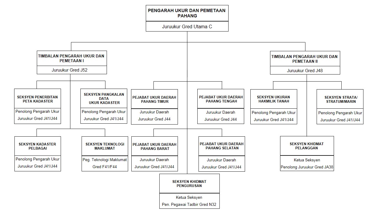
Organisation Chart
Contact Us
Department of Survey and Mapping Pahang
Director:
Sr TSALIMY BIN ABDULLAH
tsalimy@jupem.gov.my
Tel: 09-566 8511 ext. 201
Fax: 09-566 8503
District Survey Office
Eastern Pahang District Survey Office
Tingkat 3, Bangunan KWSP
Bandar Indera Mahkota
25200 KUANTAN
District Surveyor:
Sr Hj. Rostam bin Hj. Rahmat
Tel : 09 - 566 8511
Faks : 09 - 566 8503
Southern Pahang District Survey Office
Jalan Peladang
26800 KUALA ROMPIN
Tel: 09-414 5370
Fax: 09-414 6051
Western Pahang District Survey Office
Tingkat 2, Bangunan UMNO
Jalan Bukit Bius
27200 KUALA LIPIS
Tel: 09-312 1361
Fax: 09-312 2125
Central Pahang District Survey Office
Tingkat 4, Bangunan Gunasama Persekutuan
Jalan Merdeka
28000 TEMERLOH
Tel: 09-296 1228
Fax: 09-296 6943
History and Background
| Year | HISTORY OF ESTABLISHMENT | |||
|---|---|---|---|---|
| 1899-1934 |
Survey and Mapping Department in Taiping Perak responsible for the size of the title for the northern and southern Perak . Kinta District Survey Office also performs measurements of titles and earn the Certified Plan and Sheet – dead kadater by each administration . |
|||
| APRIL 1934 |
All Certified Plan , Sheet Cadastral and documents on the size of the titles that were previously approved by the Kinta District Surveyor has been submitted and stored in the DEPARTMENT Surveying and Mapping Perak , Taiping. Director of Survey and Mapping in Perak was Mr. W.A. Gummer . |
|||
| SEPTEMBER 1963 |
Department of Survey and Mapping Perak located in the old building moved to a new building in the city , Taiping and was officiated by YAB Tun Abdul Razak Bin Hussain , S.M.N , O.K.I.S , who is also Deputy Prime Minister and Minister for Rural Development . |
|||
| SEPTEMBER 1997 | Headquarters Department of Survey and Mapping silver that had been operating in Jalan Kota , Taiping moved to a new building in Jalan Dato ‘ Seri Ahmad Said , Greentown , Ipoh | |||
Organisation Chart
Contact Us
Department of Survey and Mapping Perak
Director:
Sr MOHAMED SOFIAN BIN ABU TALIB
sofian@jupem.gov.my
Jalan Dato’ Seri Ahmad Said,
Greentown, 30450 Ipoh,
Perak Darul Ridzuan.
Tel: 05-241 7181
Fax: 05-241 7151
District Survey Office
Kinta & Perak Central District Survey Office
Jalan Dato’ Seri Ahmad Said
Greentown
30450 IPOH
Tel: 05-241 7181
Fax: 05-241 7151
West Perak District Survey Office
No. 13A dan 13B
Persiaran Medan Mutiara 3
Medan Mutiara
Jalan Taiping
33000 Kuala Kangsar
Tel: 05-776 1078
Fax: 05-776 3510
Northern Perak District Survey Office
Tingkat 9, Wisma Persekutuan
Jalan Istana Larut
34000 TAIPING
Tel: 05-808 0944
Fax: 05-805 3006
Southern Perak District Survey Office
Aras 2, Bangunan Tabung Haji
Jalan Raja
35000 TAPAH
Tel: 05-401 1101
Fax: 05-401 4882
History and Background
| Year | HISTORY OF ESTABLISHMENT | |||
|---|---|---|---|---|
| 1915 | Cadastral surveying in Perlis began in 1915 under the administration of Superintendent Survey Kedah by agreement between the two Government Kedah and Perlis . | |||
| MARCH 1951 | Northern Kedah District Surveyor work assigned to carry out these measurements . Certified Plan ( Certified Plan) for the first Perlis CP 164 was approved on March 10, 1951 . | |||
| JUNE 1956 | In June 1956 , Perlis District Survey Office was officially established by Mr. Abdul Wahab bin Daud as District Surveyor Perlis . Cadastral surveying running throughout Perlis , Kubang Pasu , Kedah and Langkawi District . | |||
| NOVEMBER 1995 | Department of Survey and Mapping Perlis formed separately with JUPEM Kedah on 1 November 1995 . | |||
| DECEMBER 1995 | The first Certified Plan JUPEM Perlis PA 70000 approved on December 19, 1995 . | |||
| MAY 2009 | Implementation of e – cadastre has been in start on the 1st May 2009 and the first Certified Plan PA 100001 issued on 08 September 2010. At this time, the headquarters of the Department of Survey and Mapping Perlis is located at 6th Floor , Federal Building Kangar , Persiaran Jubilee Gold and Branch field survey in No. 7 , Taman Pengkalan Indah , Jalan Pengkalan Asam , Kangar . | |||
| JUNE 2013 | JUPEM Perlis held an opening ceremony of the Regional Surveyor ‘s Office ( JUD ) located in Kangar . The ceremony was officiated by the Director General of Survey and Mapping Malaysia ( Circular ) which was attended by senior officials and staff of JUPEM Perlis workforce . | |||
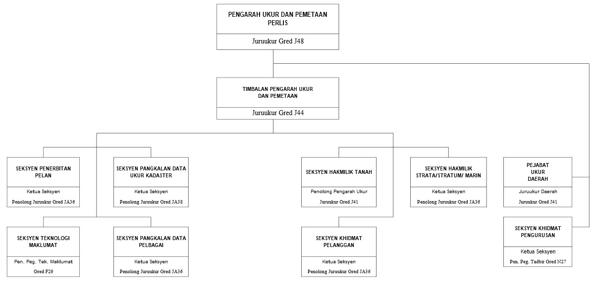
Organisation Chart
Department of Survey and Mapping Perlis
Director:
Sr MOHD KHAIRANI BIN MD YUSOP
khairani@jupem.gov.my
Level 6, Bangunan Persekutuan,
Persiaran Jubli Emas, 01000 Kangar, Perlis.
Tel: 04-977 2128
Fax: 04-977 2131
District Survey Office
Perlis District Survey Office
396F, Jalan Kolam
01000 KANGAR
Tel: 04-977 0679
Fax: 04-977 0377
History and Background
| Year | HISTORY OF ESTABLISHMENT | |||
|---|---|---|---|---|
| 1892 | Department of Survey Selangor set up and locate at Kuala Lumpur. | |||
| 1978 | Department of Survey and Mapping Selangor moved to Shah Alam, locate at Kompleks Perbadanan Kemajuan Negeri Selangor. | |||
| 1982 | Department of Survey and Mapping Selangor moved to Bangunan Sultan Salahuddin Abdul Aziz Shah. | |||
| 1995 | Selangor District Survey Office of East and West moves out to Bangunan Tabung Haji Klang. | |||
| 1998 | Department of Survey and Mapping Selangor have moved to Plaza Masalam, Seksyen 9, Shah Alam, Selangor. | |||
Organisation Chart
Contact Us
Department of Survey and Mapping Selangor
Director:
Sr LOOI KAM SENG
looi@jupem.gov.my
Level 15-01, 16-02 and 17-01 Plaza Masalam,
No, 2 Jalan Tengku Ampuan Zabedah, E9/E Seksyen 9,
40578 Shah Alam, Selangor Darul Ehsan.
Tel: 03-5514 4000
Fax: 03-5513 2613
District Survey Office
Eastern Selangor District Survey Office
Aras 2, Wisma LJT, Lorong Perak
Pusat Bandar Melawati
53100 KUALA LUMPUR
Tel: 03-4105 8191
Fax: 03-4105 5917
Western Selangor District Survey Office
Tingkat 2, Wisma Persekutuan Klang
Persiaran Bukit Raja 1/KU 1
41150 BANDAR BARU KLANG
KLANG
Tel: 03-3344 0140
Fax: 03-3341 4219
Northern Selangor District Survey Office
Lot 6-06, 6-07 & 6-08
Tingkat 6, Kompleks PKNS, Jalan Perusahaan 1
Taman IKS PKNS
45000 KUALA SELANGOR
Tel: 03-3281 2397
Fax: 03-3281 2391
History and Background
| Year | HISTORY OF ESTABLISHMENT | |||
|---|---|---|---|---|
| 1925 | Department of Survey and Mapping Negeri Terengganu was established based initially in Jalan Paya Bunga , Kuala Terengganu . | |||
| 1978 | South Terengganu District Survey Office was established based in Kemaman . | |||
| 1978 | Department of Survey and Mapping Negeri Terengganu officials moved to Level 7 and 8 , Wisma Persekutuan , Jalan Sultan Ismail , 20378 Kuala Terengganu . | |||
| 1997 | North Terengganu District Survey Office was established based on the 2nd Floor , Federal Building , 22200 Kampung Raja , Besut . | |||
| 2002 | Central Terengganu District Survey Office moved to Level 1 , Wisma Sri Amar , Jalan Sultan Ismail , 20200 Kuala Lumpur | |||
Organisation Chart
Contact Us
Department of Survey and Mapping Negeri Terengganu
Director:
Sr MOHAMAD ZIKRI BIN MAT ISA
zikri@jupem.gov.my
Level 7 & 8, Wisma Persekutuan,
Jalan Sultan Ismail, 20578 Kuala Terengganu,
Terengganu Darul Iman.
Tel: 09-622 1144/09-622 1663
Fax: 09-623 7188
District Survey Office
Northern Terengganu District Survey Office
Tingkat 2, Bangunan Persekutuan
Kampong Raja
22200 BESUT
Tel: 09-695 7014
Fax: 09-695 7015
Central Terengganu District Survey Office
Tingkat 1, Wisma Seri Amar
Jalan Sultan Ismail
20200 KUALA TERENGGANU
Tel: 09-631 7904
Fax: 09-631 7937
Southern Terengganu District Survey Office
Chukai
24000 KEMAMAN
Tel: 09-859 1289
Fax: 09-858 3177
History and Background
| Year | HISTORY OF ESTABLISHMENT | |||
|---|---|---|---|---|
| 1974 | Department of Survey and Mapping Federal Territory of Kuala Lumpur was established in line with the establishment of the Federal Territory of Kuala Lumpur and operates at Kompleks PKNS , Shah Alam . | |||
| 1979 | Department of Survey and Mapping Federal Territory of Kuala Lumpur and transferred to level 1 , Building Surveying , Jalan Semarak . | |||
| 1989 | Department of Survey and Mapping Federal Territory of Kuala Lumpur moved temporarily on the 1st floor , Angkasa Raya building , Jalan Ampang , Kuala Lumpur due to renovations in Building Surveying , Jalan Semarak . | |||
| 1991 | Department of Survey and Mapping Federal Territory of Kuala Lumpur move to level 3 and 4 , Wisma Tanah , Jalan Semarak . | |||
| 2002 | Department of Survey and Mapping Federal Province has developed its scope of activities includes the Federal Territory of Putrajaya . | |||
Organisation Chart
Contact Us
Department of Survey and Mapping Wilayah Persekutuan Kuala Lumpur & Putrajaya
Director:
Sr. SALMAH BINTI SALEH
salmahsaleh@jupem.gov.my
Level 3 & 4,
Wisma JUPEM,
Jalan Sultan Yahya Petra,
50578 Kuala Lumpur.
Tel: 03-2617 0661
Fax: 03-2693 8740
District Survey Office
Wilayah Persekutuan Kuala Lumpur& Putrajaya District Survey Office
Aras Bawah Bangunan Fotolito, Wisma JUPEM
Jalan Sultan Yahya Petra
50578 KUALA LUMPUR
Tel: 03-2617 0992
Fax: 03-2693 8740
History and Background
| Year | HISTORY OF ESTABLISHMENT | |||
|---|---|---|---|---|
| 1984 | Department of Survey and Mapping Federal Territory of Labuan was established on 16 April 1984. Labuan Island before this is under the supervision of the Department of Land and Survey Department ( JTU ) . After Labuan was declared as part of the Federal Territory , JUPEM W.P.Labuan established and its first office located in the District Office Building near Labuan Square . | |||
| 1986 | W.P.Labuan workforce has moved to Lucas Kong Building located at Jalan Merdeka Labuan town center . | |||
| 2000 | JUPEM W.P.Labuan moved to Level 7, Block 4 , Financial Park Complex. | |||
| 2010 | The National Land Code ( NLC ) first used in place of the Sabah Land Ordinance ( SLO ) used previously . | |||
Organisation Chart
Contact Us
Department of Survey and Mapping Wilayah Persekutuan Labuan
Director:
Sr NIK ZAMRI SHAM BIN NIK BAHARI SHAH
nik.zamri@jupem.gov.my
Tingkat 7, Blok 4, Kompleks Ujana Kewangan,
Peti Surat 81090,
87008 Wilayah Persekutuan Labuan.
Tel: 087-412 068 / 087-413 068 / 087-425 998(Direct dail)
Faks: 087-417 181
District Survey Office
Department of Survey and Mapping Wilayah Persekutuan Labuan
Tingkat 7, Blok 4
Kompleks Ujana Kewangan
Peti Surat 81090
87008 W.P. LABUAN
Tel: 087-412 068
History and Background
| Year | HISTORY OF ESTABLISHMENT | |||
|---|---|---|---|---|
| OCTOBER 1983 | Department of Survey and Mapping Malaysia (Sabah Branch) was established based on the Intergovernmental Committee, 1962: “12 (b) (i) Topographical and Geodetic Surveys should be Federal subjects but should continued to be carried out as at present by State Land and Survey Department as agents for the Federal Government. (ii) Cadastral Survey is State Subject “and so on through the Intergovernmental Committee of the Ministerial on December 4, 1975, which decreed: the Federal Government should take over the responsibility for carrying out topographical and geodetic surveys in Sabah and Sarawak when the Federal Government is capable and ready to do so. “in accordance with the results of both the Committee, on 10 October 1983, the Department of Survey and Mapping Malaysia (Sabah Branch) was established officially. at its inception, the Department is known as Sabah Topography and Geodesy unit consisting of two (2) sections ie Headquarters and Branch field survey region I Kota Kinabalu located at Wisma Welfare, Sembulan, Kota Kinabalu. In 1985, the Branch field survey Region II has opened branch in Tawau and field survey of Region III was opened in 1993 in Sandakan. | |||
| 1995 | The department began to be known as the Department of Surveying Mapping Malaysia ( Sabah Topography Section ) or simply JUPEM Sabah . | |||
| JANUARY 2014 | On January 1, 2014 , following the decentralization policy and Mapping Division workforce restructuring through the Establishment Warrant No. 128 of 2013, amended Section Topography Sabah to Sabah Topographic Mapping Section | |||
Organisation Chart
No record(s)
Contact Us
Director:
Sr SHAFFRI BIN BAUDI
shaffri@jupem.gov.my
Level 3, Block B, Kompleks Kuwasa,
Jalan Karamunsing, 88840 Kota Kinabalu,
Sabah.
Tel: 088-212835/6
Fax: 088-231243
Territory Topography Survey Office
Topography Survey Office Territory I, Kota Kinabalu
Lot 3, Taman Perindustrian Teknologi
Batu 7, Jalan Tuaran Lama, Inanam
88450 KOTA KINABALU
Tel: 088-384429
Fax: 088-384430
Topography Survey Office Territory II, Tawau
TB4661 & TB4662 , Jalan Dominic
91018 TAWAU
Tel: 089-778120
Fax: 089-777624
Topography Survey Office Territory III, Sandakan
Tingkat 6, Bangunan Urusetia Negeri
Peti Surat 114, Pejabat Pos Jalan Utara
90307 SANDAKAN
Tel: 089-674797
Fax: 089-674997
History and Background
No Record(s) Found
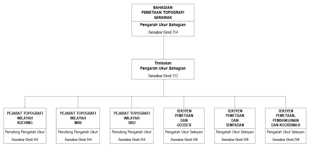
Organisation Chart
Contact Us
Sarawak Topography
Director:
Sr SYLVESTER LUTA ANAK BULI
luta@jupem.gov.my
Level 7, Bangunan Sultan Iskandar,
Jalan Simpang Tiga, 93578 Kuching,
Sarawak.
Tel: 082-420763
Fax: 082-245420
Territory Survey Office
Kuching Territory Survey Office
No.15, Tingkat 2, Lot 2387, Bormill Commercial Estate
Jalan Tun Ahmad Zaidi Adruce
93150 KUCHING
Tel: 082-423763
Fax: 082-426921
Miri Territory Topography Survey Office
Blok B, Tingkat 1
Bangunan Gunasama Persekutuan
Jalan Cahaya Lopeng
98000 MIRI
Tel: 085-442066
Fax: 085-433022
Sibu Territory Topography Survey Office
Pejabat Topografi Wilayah Sibu,
No. 7 & No. 9, Bangunan Hamimas (Lot 3625 & 3626),
Lorong Kampung Nangka 8A,
Jalan Kampung Nangka,
96000 Sibu, Sarawak
Tel: 084-314797
Fax: 084318795
Ibu Pejabat JUPEM
Wisma JUPEM, Jalan Sultan Yahya Petra,
50578 Kuala Lumpur.
Negeri Johor
Blok A, Wisma Persekutuan,
Jalan Air Molek, 80000,
Johor Bahru, Johor
Negeri Kedah
09000 Kulim,
Kedah Darul Aman.
Negeri Kelantan
Negeri Melaka
Negeri Sembilan
Negeri Pahang
Jalan Tengku Muhammad,
25050, Kuantan,
Pahang Darul Makmur.
Negeri Perak
Negeri Perlis
Negeri Pulau Pinang
Negeri Selangor
Negeri Terengganu
Wilayah Persekutuan Kuala Lumpur & Putrajaya
Wisma JUPEM, Jalan Sultan Yahya Petra,
50578 Kuala Lumpur.
Negeri Sarawak
Wilayah Persekutuan Labuan
Topografi Sabah
Inisiatif Kemajuan Kerjaya Laluan Pakar Bidang Khusus (Subject Matter Expert - SME) yang diperkenalkan oleh Kerajaan adalah sejajar dengan Rancangan Malaysia Kesebelas (RMKe11) mengenai pengukuhan pengurusan bakat untuk perkhidmatan awam masa hadapan. Di samping itu, Dokumen Kajian Separuh Penggal RMKe11 menggariskan kemajuan kerjaya pegawai perkhidmatan awam akan dilaksanakan dengan lebih telus berdasarkan merit dan prestasi dalam perkhidmatan.
Melalui pewujudan laluan SME Kerajaan dapat mengiktiraf pegawai yang memiliki keupayaan intelektual, kepakaran yang tinggi serta berpengalaman luas dalam bidang kepakaran serta menjadi sumber rujukan dalam dan luar organisasinya ke arah memastikan pengekalan bakat terbaik dan berkepakaran tinggi dalam perkhidmatan awam.
Proses pengiktirafan pegawai SME dalam perkhidmatan awam bermula daripada fasa perancangan iaitu penentuan bidang kepakaran, penetapan kriteria penilaian, unjuran keperluan dan seterusnya perakuan ke Lembaga Kenaikan Pangkat Perkhidmatan Awam (LKPPA) untuk kelulusan bidang dan kriteria penilaian. Permohonan ke laluan SME boleh dikemukakan setelah bidang kepakaran diluluskan dan dipersetujui oleh LKPPA. Pegawai yang diiktiraf sebagai pegawai SME oleh Lembaga Kenaikan Pangkat Perkhidmatan Awam (LKPPA) akan diberi pemangkuan dan seterusnya kenaikan pangkat pada 1 gred yang lebih tinggi secara Khas Untuk Penyandang (KUP) tertakluk melepasi tapisan kepakaran yang ketat. Pegawai SME perlu melaksanakan Penugasan Khas Pakar Bidang Khusus (SME Special Assignment - SSA) di samping tugasan hakiki berdasarkan jawatan bagi tujuan pengekalan dan peningkatan di laluan SME.
Dengan wujudnya pegawai SME yang berterusan menyumbangkan kepakaran dalam perkhidmatan awam, negara akan memperoleh manfaat jangka panjang melalui sumbangan kepakaran dalam perkhidmatan awam di samping memastikan berlakunya pemindahan kepakaran secara sistematik dan efektif dalam kalangan penjawat awam di bawah pelan penggantian dan pembangunan bakat perkhidmatan awam. Secara tidak langsung kebergantungan kepakaran daripada pihak luar dapat dikurangkan dan penjimatan kos dapat dihasilkan selaras dengan falsafah SME.
Kerajaan telah menguatkuasakan Pekeliling Perkhidmatan Bilangan 7 Tahun 2016 Kemajuan Kerjaya Laluan Pakar Bidang Khusus (Subject Matter Expert - SME) pada 20 Disember 2016 bertujuan untuk memaklumkan garis panduan pelaksanaan laluan SME dalam perkhidmatan awam persekutuan.
Lembaga Kenaikan Pangkat Perkhidmatan Awam (LKPPA) Bilangan 6 Tahun 2018 yang bersidang pada 5 Oktober 2018 melalui surat JPA.BK(S)226/6/4/18(10) bertarikh 29 Oktober 2018 telah bersetuju meluluskan bidang dan sub bidang bagi Kemajuan Kerjaya Laluan Pakar Bidang Khusus (Subject Matter Expert - SME) bagi skim perkhidmatan Juruukur.

-
Gred:
Juruukur Gred Khas C (KUP) (SME) -
Bidang Kepakaran:
SME Pemetaan (Pemetaan Light Detection and Ranging (LiDAR)/ Synthetic Aperture Radar (SAR)) -
Tahap:
4 -
E-mel::
hazri@jupem.gov.my -
Tel::
03-2617 0831
Sr HAZRI BIN HASSAN
Timbalan Ketua Pengarah Ukur Dan Pemetaan II

-
Gred:
Juruukur Gred Khas C (KUP) (SME) -
Bidang Kepakaran:
SME Kadaster (Ukuran Kadaster) -
Tahap:
4 -
E-mel::
looi@jupem.gov.my -
Tel::
03-2617 0870
Sr LOOI KAM SENG
Pengarah Ukur Seksyen Perundangan Kadaster, Bahagian Kadaster

-
Gred:
Juruukur Gred J48 (KUP) (SME) -
Bidang Kepakaran:
SME Kadaster (Penawanan Data Terrestrial dan 3D Modelling) -
Tahap:
1 -
E-mel::
jasmari@jupem.gov.my -
Tel::
03-2617 0662
Sr JASMARI BIN JAMALUDIN
Timbalan Pengarah Ukur dan Pemetaan JUPEM Wilayah Persekutuan Kuala Lumpur/Putrajaya

-
Gred:
Juruukur Gred J48 (KUP) (SME) -
Bidang Kepakaran:
SME Kadaster (Penawanan Data Terrestrial dan 3D Modelling) -
Tahap:
1 -
E-mel::
nurzurairah@jupem.gov.my -
Tel::
03-2617 0516
Sr NUR ZURAIRAH BINTI ABDUL HALIM
Penolong Pengarah Ukur Seksyen Naziran Kadaster, Bahagian Kadaster

-
Gred:
Juruukur Gred J48 (KUP) (SME) -
Bidang Kepakaran:
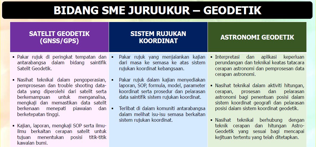
SME Geodetik (Sistem Rujukan Koordinat) -
Tahap:
1 -
E-mel::
yeap@jupem.gov.my -
Tel::
03-2617 0703
Sr YEAP WEI CHIEN
Penolong Pengarah Ukur Seksyen Pengurusan Maklumat Geospatial,Bahagian Geospatial Pertahanan

-
Gred:
Juruukur Gred J48 (KUP) (SME) -
Bidang Kepakaran:
SME Persempadanan (Persempadanan Darat) -
Tahap:
1 -
E-mel::
fuad@jupem.gov.my -
Tel::
03-5514 4000
Sr MOHAMAD FUAD BIN KAHAR
Juruukur Daerah Selangor Timur

-
Gred:
Juruukur Gred J48 (KUP) (SME) -
Bidang Kepakaran:
SME Geodetik ( Satelit Geodetik(GPS)) -
Tahap:
1 -
E-mel::
asyran@jupem.gov.my -
Tel::
03-2617 0928
Sr DR. MUHAMMAD ASYRAN BIN CHE AMAT
Penolong Pengarah Ukur, Seksyen Infrastruktur Rujukan Spatial, Bahagian Ukur Geodetik
- Pembentangan SSA- Sr Hazri bin Hassan
- Pembentangan SSA- Sr Looi Kam Seng
- Pembentangan SSA- Sr Zulkifli bin Sidek
- Pembentangan SSA- Sr Jasmari bin Jamaludin
- Pembentangan SSA- Sr Nur Zurairah binti Andul Halim
- Pembentangan SSA- Sr Yeap Wei Chien
- Pembentangan SSA- Sr Mohamad Fuad bin Kahar
- Pembentangan SSA- Sr Dr. Muhammad Asyran bin Che Amat
Bagi calon-calon yang berminat boleh membuat semakan menggunakan borang penilaian kriteria bagi kemasukan
laluan SME melalui pautan seperti berikut Borang Penilaian Kriteria Bagi Kemasukan Laluan
SME Skim Perkhidmatan Juruukur untuk mengetahui status
kelayakan masing-masing. Calon-calon perlu memperoleh markah penilaian SME 83% dan ke atas bagi membolehkan
permohonan mereka dipertimbangkan oleh Jawatankuasa Kerja SME JUPEM.
- LAMPIRAN
- IKLAN PERMOHONAN KEMASUKAN KE LALUAN PAKAR BIDANG KHUSUS (SUBJECT MATTER EXPERT - SME) DI JABATAN UKUR DAN PEMETAAN MALAYSIA
Sebarang pertanyaan berhubung urusan berkaitan bidang kepakaran boleh diajukan kepada pegawai-pegawai seperti berikut:
-
Email:
dhaniel.sufian@jupem.gov.my -
Ketua Penolong Pengarah
Seksyen Sumber Manusia, Bahagian Khidmat Pengurusan -
Tel:
03-2617 0806
Encik Mohd Dhaniel bin Mohd Sufian
-
Email:
hazwan@jupem.gov.my -
Penolong Pegawai Tadbir
Seksyen Sumber Manusia, Bahagian Khidmat Pengurusan -
Tel:
03-2617 0783
Encik Hazwan Fitri bin Harun
-
Email:
halina@jupem.gov.my -
Ketua Pembantu Tadbir
Seksyen Sumber Manusia, Bahagian Khidmat Pengurusan -
Tel:
03-2617 0802
Puan Halina binti Abu Chit
-
Email:
ahmad.nazlie@jupem.gov.my -
Pengarah Ukur
Seksyen Perancangan dan Dasar, Bahagian Perancangan dan Korporat -
Tel:
03-2617 0846
Sr Ahmad Nazlie bin Muhamad
-
Email:
hishammudin@jupem.gov.my -
Penolong Pengarah Ukur
Seksyen Perancangan dan Dasar, Bahagian Perancangan dan Korporat -
Tel:
03-2617 0849
