


Assalamualaikum Warahmatullahi Wabarakatuh and greetings.
Welcome and thank you for visiting JUPEM Geoportal, the official portal of the Department of Survey and Mapping, Malaysia (JUPEM). It is my hope that this portal will very much facilitate our users in their transactions with JUPEM to obtain up-to-date survey and mapping information.
The creation of JUPEM Geoportal is one of our strategies to introduce and promote JUPEM as an agency under the Ministry of Natural Resources, Environment and Climate Change (nrecc). JUPEM Geoportal interactively provides information on JUPEM such as its organisation structure, activities, services, products and publications. Also available are knowledge corner, photo gallery, video and latest events in JUPEM. The portal will be constantly maintained and updated to ensure only relevant and up-to-date information being published and offered.
I am proud to highlight that in line with our country’s progress towards becoming a developed nation, JUPEM plays an important role as an advisor to the Government pertaining to survey and mapping activities. The entrusted task of demarcating states’ and country’s boundaries are imperative to safeguard the nation’s sovereignty. These activities are also vital for the socio-economic development of the nation.
Since its formation, JUPEM has undertaken various restructuring and modernization programs and projects in order to improve the quality of its services and products. JUPEM has always strived to be compatible with the latest technology development in survey and mapping activities ever since its establishment, from the conventional era up to the current geospatial solutions.
I would like to take this opportunity to welcome any constructive views and opinions to further enhance the quality of our services for the benefit of all.
Again, thank you for visiting this portal.
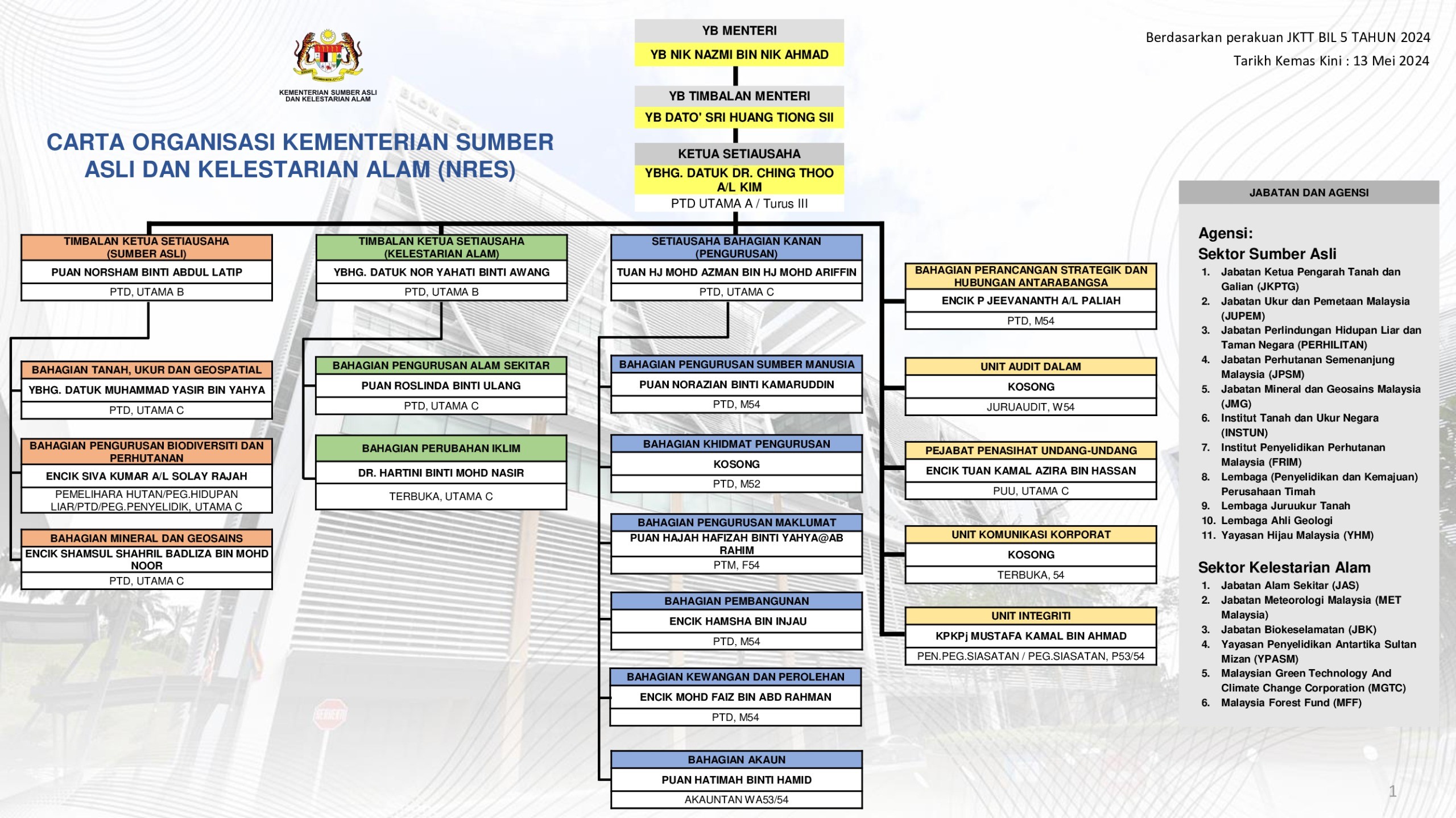
DIRECTOR GENERAL OF SURVEY AND MAPPING
MALAYSIA
- Jawatankuasa Pemetaan dan Data Spatial Negara(JPDSN)
- Jawatankuasa Teknikal TC 2 Standard Maklumat Geografi/Geomatik
- Jawatankuasa Kebangsaan Nama-nama Geografi (JKNG)
- Jawatankuasa Penyelidikan Geospatial Kebangsaan
- Jawatankuasa Teknikal Penandaan dan Pengukur Sempadan
- Jawatankuasa Penyelaras MyGDI Kebangsaan (JPMK)
- Jawatankuasa Geospatial Pertahanan
- Jawatankuasa Teknikal Kalendar Islam
- Jawatankuasa Hidrografi Kebangsaan
- United Nation Global Geospatial Information Management Asia Pacific (UN-GGIM-AP)
- United Nations Group of Expert on Global Geospatial Information Management (UN-GGIM)
- United Nation Group of Experts on Geographical Names (UNGEGN)
- ISO/TC 211 for Geographic Information / Geomatics
- International Steering Committee for Global Mapping (ISCGM)
- International Cartographics Association (ICA)
- International Society for Photogrammetry and Remote Sensing (ISPRS)
- International Association of Geodesy (IAG)
- International Federation of Surveyors (FIG)
| NO | YEAR | AWARD |
|---|---|---|
| 1 | 2003 | Survey Methos for the Proprietary Rights Production of Organized Village Settlement |
| 2 | 2002 | Orthophoto Maps |
| 3 | 2001 | Electronics Maps Development (e-map) |
| 4 | 1998 | Introduction of Measurements For Cluster Land |
| 5 | 1997 | |
| 6 | 1996 | Electronic Site Work Book Development |
| NO | YEAR | AWARD |
|---|---|---|
| 1 | 2023 | |
| 2 | 2020 |
|
| 3 | 2019 |
|
| 4 | 2018 |
|
| 5 | 2017 |
|
| 6 | 2016 |
|
| 7 | 2015 |
|
| 8 | 2004 |
|
| 9 | 2013 |
|
| 10 | 2012 |
|
| 11 | 2011 | Overall Performance Sports Biennial, NRE : 4th in Ministry Level |
| 12 | 2011 |
|
| 13 | 2011 | 5S Practice Certification by MPC |
| 14 | 2011 | Award for Excellence in Achievement Rating 5 Star in Malaysia Government Portals and Websites Assessement 2011 by MDEC |
| 15 | 2011 | Best Human Resource Management Award: 3rd Place for Ministry Level |
| 16 | 2011 | Kumpulan Inovasi dan Kreativiti (KIK) Best Category Technical and Non-Technical Award: 2nd Place for Ministry Level |
| 17 | 2011 | MS ISO 9001 : 2008 (Quality Management System Requirements) |
| 18 | 2010 |
|
| 19 | 2009 |
|
| 20 | 2008 |
|
| 21 | 2008 | ESRI USA Award, Best Achievement Award In GIS |
| 22 | 2005 | Sabah Public Services Quality Award (AQPA) |
| 23 | 2004 | Information Technology Premiere Award Field To Finish |
| 24 | 2003 | Integraph USA Award, Geospatial Achivement Award |
| 25 | 2002 |
|
| 26 | 2001 | The Best Web Site For Public Sector Awards |
| 27 | 2000 | ESRI USA Award, Best Achievement Award In GIS |
|
BIL. |
PERJANJIAN PERSEFAHAMAN/ MEMORANDUM OF UNDERSTANDING (MoU) |
TARIKH PERJANJIAN |
|
1 |
Memorandum of Understanding Between the Government of Malaysia and the Government of The Kingdom of Thailand for The Construction and Maintenance of a Single Barrier in The Area Between Bp20a/12 And Bp 23/104 in Area III (BP16 - BP 27), 2018 |
02 Ogos 2018 |
|
2 |
Kota Kinabalu, Sabah Supplementary Memorandum of Understanding 2003 |
29 Julai 2003 |
|
3 |
Chiang Mai Memorandum of Understanding Concerning The Area Between Bp 13/16 And Bp 15c In Area Vi (Bp Sc - Bp 16) of The Common Land Boundary Between Malaysia and The Kingdom of Thailand 2000 |
28 April 2000 |
|
4 |
Johor Bahru Supplementary Memorandum of Understanding 1999 |
19 Mei 1999 |
|
5 |
Chiang-Mai Memorandum of Understanding 1986 |
29 Mac 1986 |
|
6 |
Kuala Lumpur Memorandum of Understanding 1985 |
02 Julai 1985 |
|
7 |
Bangkok Memorandum of Understanding 1984 |
09 Mei 1984 |
|
8 |
Johor Bahru Memorandum of Understanding 1983 |
25 Mei 1983 |
|
9 |
Bangkok Memorandum of Understanding 1982 |
08 September 1982 |
|
10 |
Kuala Lumpur Memorandum of Understanding 1981 |
11 September 1981 |
|
11 |
Bangkok Memorandum of Understanding 1980 |
26 Jun 1980 |
|
12 |
Kuala Lumpur Memorandum of Understanding 1979 |
07 Julai 1979 |
|
13 |
Bangkok Memorandum of Understanding 1978 |
18 Julai 1978 |
|
14 |
Kuala Lumpur Memorandum of Understanding 1977 |
21 Julai 1977 |
|
15 |
Bangkok Memorandum of Understanding 1976 |
11 Ogos 1976 |
|
16 |
Memorandum of Understanding on the Joint Survey of Common Land Boundary Between Malaysia - Thailand |
08 September 1972 |
|
BIL. |
PERJANJIAN PERSEFAHAMAN/ MEMORANDUM OF UNDERSTANDING (MoU) |
TARIKH PERJANJIAN |
|
1 |
Memorandum of Understanding between The Government of Malaysia and The Government of the Republic of Indonesia on the Demarcation and Survey of the International Boundary between Malaysia (Sabah & Sarawak) and Indonesia (Kalimantan Utara & Kalimantan Barat): Sabah - Area II & III |
21 November 2019 |
|
2 |
Memorandum of Understanding between The Government of Malaysia and The Government of the Republic of Indonesia on the Demarcation and Survey of the International Boundary between Malaysia (Sabah & Sarawak) and Indonesia (Kalimantan Utara & Kalimantan Barat): Sabah- Area II & III and Sarawak - Area III |
10 Oktober 2018 |
|
3 |
Memorandum of Understanding between The Government of Malaysia and The Government of the Republic of Indonesia on the Demarcation and Survey of the International Boundary between Malaysia (Sabah & Sarawak) and Indonesia (Kalimantan Utara & Kalimantan Barat): Sabah - Area II |
07 Jun 2017 |
|
4 |
Memorandum of Understanding between The Government of Malaysia and The Government of the Republic of Indonesia on the Demarcation and Survey of the International Boundary between Malaysia (Sabah & Sarawak) and Indonesia (Kalimantan Utara & Kalimantan Barat): Sarawak - Area III, VII & XIX |
13 April 2006 |
|
5 |
Memorandum of Understanding between The Government of Malaysia and The Government of the Republic of Indonesia on the Demarcation and Survey of the International Boundary between Malaysia (Sabah & Sarawak) and Indonesia (Kalimantan Utara & Kalimantan Barat): Sarawak - Area III & IV |
4 Februari 2005 |
|
6 |
Memorandum of Understanding between The Government of Malaysia and The Government of the Republic of Indonesia on the Demarcation and Survey of the International Boundary between Malaysia (Sabah & Sarawak) and Indonesia (Kalimantan Utara & Kalimantan Barat): Sarawak - Area IV |
31 Oktober 2001 |
|
7 |
Memorandum of Understanding between The Government of Malaysia and The Government of the Republic of Indonesia on the Demarcation and Survey of the International Boundary between Malaysia (Sabah & Sarawak) and Indonesia (Kalimantan Utara & Kalimantan Barat): Sarawak - Area XXI & XXII |
09 November 2000 |
|
8 |
Memorandum of Understanding between The Government of Malaysia and The Government of the Republic of Indonesia on the Demarcation and Survey of the International Boundary between Malaysia (Sabah & Sarawak) and Indonesia (Kalimantan Utara & Kalimantan Barat): Sarawak - Area XX |
26 Februari 2000 |
|
9 |
Memorandum of Understanding between The Government of Malaysia and The Government of the Republic of Indonesia on the Demarcation and Survey of the International Boundary between Malaysia (Sabah & Sarawak) and Indonesia (Kalimantan Utara & Kalimantan Barat): Sarawak - Area XIX |
30 April 1999 |
|
10 |
Memorandum of Understanding between The Government of Malaysia and The Government of the Republic of Indonesia on the Demarcation and Survey of the International Boundary between Malaysia (Sabah & Sarawak) and Indonesia (Kalimantan Utara & Kalimantan Barat): Sarawak - Area XVII & XVIII |
25 April 1998 |
|
11 |
Memorandum of Understanding between The Government of Malaysia and The Government of the Republic of Indonesia on the Demarcation and Survey of the International Boundary between Malaysia (Sabah & Sarawak) and Indonesia (Kalimantan Utara & Kalimantan Barat): Sarawak - Area XVI & XVII |
7 Mac 1997 |
|
12 |
Memorandum of Understanding between The Government of Malaysia and The Government of the Republic of Indonesia on the Demarcation and Survey of the International Boundary between Malaysia (Sabah & Sarawak) and Indonesia (Kalimantan Utara & Kalimantan Barat): Sabah- Area II and Sarawak - Area XV |
6 Januari 1996 |
|
13 |
Memorandum of Understanding between The Government of Malaysia and The Government of the Republic of Indonesia on the Demarcation and Survey of the International Boundary between Malaysia (Sabah & Sarawak) and Indonesia (Kalimantan Utara & Kalimantan Barat): Sabah- Area II and Sarawak - Area XV |
25 Januari 1995 |
|
14 |
Memorandum of Understanding between The Government of Malaysia and The Government of the Republic of Indonesia on the Demarcation and Survey of the International Boundary between Malaysia (Sabah & Sarawak) and Indonesia (Kalimantan Utara & Kalimantan Barat): Sabah- Area II and Sarawak - Area XV |
29 Jun 1994 |
|
15 |
Memorandum of Understanding between The Government of Malaysia and The Government of the Republic of Indonesia on the Demarcation and Survey of the International Boundary between Malaysia (Sabah & Sarawak) and Indonesia (Kalimantan Utara & Kalimantan Barat): Sabah- Area III and Sarawak - Area XV |
20 Oktober 1993 |
|
16 |
Memorandum of Understanding between The Government of Malaysia and The Government of the Republic of Indonesia on the Demarcation and Survey of the International Boundary between Malaysia (Sabah & Sarawak) and Indonesia (Kalimantan Utara & Kalimantan Barat): Sabah- Area I & II and Sarawak - Area VII |
16 September 1992 |
|
17 |
Memorandum of Understanding between The Government of Malaysia and The Government of the Republic of Indonesia on the Demarcation and Survey of the International Boundary between Malaysia (Sabah & Sarawak) and Indonesia (Kalimantan Utara & Kalimantan Barat): Sarawak - Area VII |
28 Februari 1987 |
|
18 |
Memorandum of Understanding between The Government of Malaysia and The Government of the Republic of Indonesia on the Demarcation and Survey of the International Boundary between Malaysia (Sabah & Sarawak) and Indonesia (Kalimantan Utara & Kalimantan Barat): Sarawak - Area V |
30 Mei 1984 |
|
19 |
Memorandum of Understanding between The Government of Malaysia and The Government of the Republic of Indonesia on the Demarcation and Survey of the International Boundary between Malaysia (Sabah & Sarawak) and Indonesia (Kalimantan Utara & Kalimantan Barat): Sarawak - Area IV |
10 Julai 1980 |
|
20 |
Memorandum of Understanding between The Government of Malaysia and The Government of the Republic of Indonesia on the Demarcation and Survey of the International Boundary between Malaysia (Sabah & Sarawak) and Indonesia (Kalimantan Utara & Kalimantan Barat): Sarawak - Area I, II & III |
18 November 1978 |
|
21 |
Memorandum of Understanding between The Government of Malaysia and The Government of the Republic of Indonesia on the Demarcation and Survey of the International Boundary between Malaysia (Sabah & Sarawak) and Indonesia (Kalimantan Utara & Kalimantan Barat): Sabah - Area I & Sarawak - Area I & II |
13 Disember 1976 |
|
22 |
Memorandum of Understanding between The Government of Malaysia and The Government of the Republic of Indonesia on the Demarcation and Survey of the International Boundary between Malaysia (Sabah & Sarawak) and Indonesia (Kalimantan Utara & Kalimantan Barat): Sabah - Area I & Sarawak - Area I & II |
23 Ogos 1976 |
|
23 |
Memorandum of Understanding between The Government of Malaysia and The Government of the Republic of Indonesia on the Demarcation and Survey of the International Boundary between Malaysia (Sabah & Sarawak) and Indonesia (Kalimantan Utara & Kalimantan Barat): For Purpose and Undertaking Survey |
00 Januari 1900 |
BIL. | PERJANJIAN PERSEFAHAMAN/ MEMORANDUM OF UNDERSTANDING (MoU) | TARIKH PERJANJIAN |
1 | Treaty between Malaysia and the Republic of Indonesia relating to the delimitation of the territorial seas of the two countries in the Sulawesi Sea | 8 Jun 2023 |
2 | Treaty between Malaysia and the Republic of Indonesia relating to the delimitation of the territorial seas of the two countries in the Southernmost Part of The Straits of Malacca | 8 Jun 2023 |
3 | Exchange of Letters Malaysia – Brunei | 16 Mac 2009 |
4 | 1995 Agreement between the Government of Malaysia and the Government of the Republic of Singapore to Delimit Precisely the Territorial Waters Boundary in Accordance with the Straits Settlements and Johore Territorial Waters Agreement 1927 | 7 Ogos 1995 |
5 | Memorandum of Understanding between the Government of Malaysia and the Government of the Kingdom of Thailand relating to the delimitation of the Continental Shelves between the two countries | 24 Oktober 1979 |
6 | Treaty between Malaysia and the Kingdom of Thailand relating to the delimitation of the Territorial Seas of the two countries | 24 Oktober 1979 |
7 | Agreement between the Pengarah Pemetaan Negara, Malaysia and the Kepala Jawatan Hidro-Oceanografi, Tentara Nasional Indonesia Angkatan Laut, Relating to the Fundamental Point of the Common Datum | 12 Disember 1974 |
8 | Agreement between the Government of Malaysia, the Government of the Republic of Indonesia and the Government of the Kingdom of Thailand relating to the delimitation of the Continental Shelf Boundaries in the Northern Part of the Straits of Malacca | 21 Disember 1971 |
9 | Memorandum of Understanding between the Director, Royal Thai Survey Department and the Director of National Mapping, Malaysia | 20 Mei 1971 |
10 | Memorandum of Understanding signed between Direktur, Direktorat Hidrografi Angkatan Laut, Republic Inodnesia dan Pengarah Pemetaan Negara Malaysia at Kuala Lumpur | 11 Februari 1971 |
11 | Treaty between Malaysia and the Government of the Republic of Indonesia relating to the delimitation of the Territorial Seas of the two countries in the Straits of Malacca | 17 Mac 1970 |
12 | Agreement between the Government of Malaysia and the Government of the Republic of Indonesia relating to the delimitation of the Continental Shelf between the two countries initialled | 27 Oktober 1969 |
13 | The Sarawak (Definition of Boundaries) Order in Council | 11 September 1958 |
14 | The North Borneo (Definition of Boundaries) Order in Council | 11 September 1958 |
15 | Convention between His Majesty in respect of the United Kingdom and the President of the United States of America regarding the Boundary between the Philippine Archipelago and the state of North Borneo, Anglo-American Treaty | 2 Januari 1930 |
16 | Treaty between Great Britain and Siam | 10 Mac 1909 |
17 | Treaty of Paris between USA and Spain | 10 Disember 1898 |
BIL. | PERJANJIAN PERSEFAHAMAN/ MEMORANDUM OF UNDERSTANDING (MoU) | TARIKH PERJANJIAN |
1 | Perjanjian Sempadan Darat (Kedah - Perlis) | 29 Mei 2023 |
2 | Perjanjian Sempadan Maritim (Kedah - Perlis) | 29 Mei 2023 |
3 | Perjanjian Sempadan Darat (Selangor - Negeri Sembilan) | 4 Julai 2022 |
4 | Perjanjian Sempadan Maritim (Melaka - Negeri Sembilan) | 15 Oktober 2019 |
5 | Perjanjian Sempadan Darat (Melaka - Negeri Sembilan) | 2 Julai 2019 |
6 | Perjanjian Sempadan Darat (Terengganu - Kelantan) | 20 Jun 2019 |
7 | Perjanjian Sempadan Darat (Pahang - Selangor) | 9 Mac 2018 |
8 | Perjanjian Sempadan Darat (Pahang - Negeri Sembilan) | 29 Oktober 2013 |
9 | Perjanjian Sempadan Darat (Pahang - Perak) | 26 Jun 2012 |
10 | Perjanjian Sempadan Darat (Pahang - Terengganu) | 19 Mac 2007 |
11 | Akta A1095 (Selangor - Wilayah Persekutuan Putrajaya) | 1 Februari 2001 |
12 | Akta 1982 (Kedah - Pulau Pinang) | 1982 |
13 | Akta A206 (Selangor - Wilayah Persekutuan Kuala Lumpur) | 1 Februari 1974 |
14 | Gazette (Kedah - Perlis) | 31 Disember 1953 & 28 Januari 1954 |
15 | Agreement between The United Kingdom and Sultan Perak (Perak - Pulau Pinang) | 28 Jun 1939 |
16 | Agreement dan Gazette (Perak - Kedah) | 4 Mac 1912 & 10 Mac 1933 |
17 | Gazette dan surat menyurat antara Residen 1927 - 1929 (Pahang - Selangor) | 11 Jun 1911 |
18 | Gazette (Selangor - Negeri Sembilan) | 5 November 1909 |
19 | Gazette (Perak - Selangor) | 12 April 1901 |
20 | Gazette (Perak - Pulau Pinang) | 6 Julai 1900 & 18 Julai 1902 |
21 | Gazette (Pahang - Kelantan) | 1 Jun 1900 |
22 | Gazette (Perak - Kedah) | 15 Mei 1900 |
23 | Agreement Signed November 29th 1899 (Perak - Kedah, Pahang - Perak, Perak - Kelantan, Kelantan - Pahang & Pahang - Terengganu) | 29 November 1899 |
24 | Award Johore - Malacca, Johore - Johol and Johore - Pahang Boundaries (Pahang - Negeri Sembilan, Johor - Melaka, Johor - Negeri Sembilan & Johor - Pahang) | 18 Februari 1898 |
25 | Jelebu 24 August 1883, surat menyurat antara Gabenor-Bendahara 1884-1885 (Pahang - Sembilan) | 24 Ogos 1883 |
26 | Agreement Between Selangor and Sungai Ujong (Selangor - Negeri Sembilan) | 10 Februari 1878 |
27 | Treaty of friendship 1862 (Johor - Pahang) | 1862 |
28 | Cession of Cape Rachado (Negeri Sembilan - Melaka) | 23 Ogos 1860 |
29 | Treaty Between Britain and Siam 1839 (Kedah - Pulau Pinang) | 1839 |
30 | Rumbowe & Johole 1833 (Negeri Sembilan - Melaka) | 1933 |
31 | Frontier and Boundary Treaties, 1831 (Quedah, 1831) (Kedah - Pulau Pinang) | 1831 |
32 | Treaty with Perak and Salangore 1825 (Perak - Selangor) | 1825 |


YBrs. Sr HAZRI BIN HASSAN
DIRECTOR GENERAL OF SURVEY AND MAPPING MALAYSIA

YBrs. Sr DR. AHMAD SANUSI BIN CHE COB
DEPUTY DIRECTOR GENERAL OF SURVEY AND MAPPING I

YBrs. Sr MUHAMMAD SALIM BIN MOHAMMED ASARI
DEPUTY DIRECTOR GENERAL OF SURVEY AND MAPPING II

YBrs. Sr DR. AHMAD SANUSI BIN CHE COB
DEPUTY DIRECTOR GENERAL OF SURVEY AND MAPPING I
Email: @jupem.gov.my
Tel: 03-2617 0890
Fax: 03-2697 0681

Click to enlarge


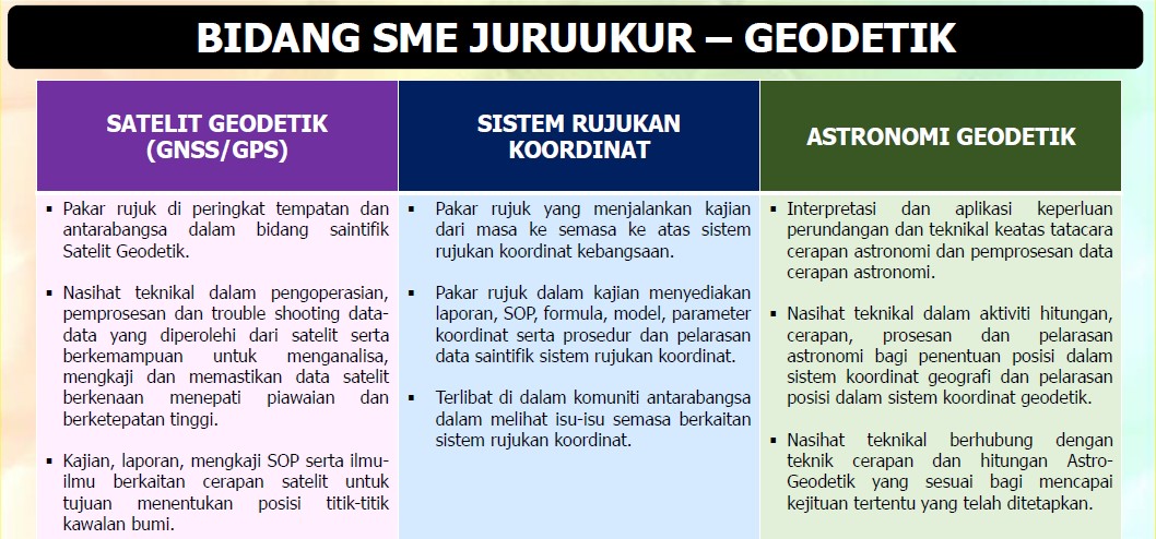
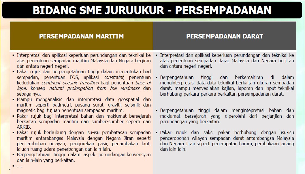
Inisiatif Kemajuan Kerjaya Laluan Pakar Bidang Khusus (Subject Matter Expert - SME) yang diperkenalkan oleh Kerajaan adalah sejajar dengan Rancangan Malaysia Kesebelas (RMKe11) mengenai pengukuhan pengurusan bakat untuk perkhidmatan awam masa hadapan. Di samping itu, Dokumen Kajian Separuh Penggal RMKe11 menggariskan kemajuan kerjaya pegawai perkhidmatan awam akan dilaksanakan dengan lebih telus berdasarkan merit dan prestasi dalam perkhidmatan.
Melalui pewujudan laluan SME Kerajaan dapat mengiktiraf pegawai yang memiliki keupayaan intelektual, kepakaran yang tinggi serta berpengalaman luas dalam bidang kepakaran serta menjadi sumber rujukan dalam dan luar organisasinya ke arah memastikan pengekalan bakat terbaik dan berkepakaran tinggi dalam perkhidmatan awam.
Proses pengiktirafan pegawai SME dalam perkhidmatan awam bermula daripada fasa perancangan iaitu penentuan bidang kepakaran, penetapan kriteria penilaian, unjuran keperluan dan seterusnya perakuan ke Lembaga Kenaikan Pangkat Perkhidmatan Awam (LKPPA) untuk kelulusan bidang dan kriteria penilaian. Permohonan ke laluan SME boleh dikemukakan setelah bidang kepakaran diluluskan dan dipersetujui oleh LKPPA. Pegawai yang diiktiraf sebagai pegawai SME oleh Lembaga Kenaikan Pangkat Perkhidmatan Awam (LKPPA) akan diberi pemangkuan dan seterusnya kenaikan pangkat pada 1 gred yang lebih tinggi secara Khas Untuk Penyandang (KUP) tertakluk melepasi tapisan kepakaran yang ketat. Pegawai SME perlu melaksanakan Penugasan Khas Pakar Bidang Khusus (SME Special Assignment - SSA) di samping tugasan hakiki berdasarkan jawatan bagi tujuan pengekalan dan peningkatan di laluan SME.
Dengan wujudnya pegawai SME yang berterusan menyumbangkan kepakaran dalam perkhidmatan awam, negara akan memperoleh manfaat jangka panjang melalui sumbangan kepakaran dalam perkhidmatan awam di samping memastikan berlakunya pemindahan kepakaran secara sistematik dan efektif dalam kalangan penjawat awam di bawah pelan penggantian dan pembangunan bakat perkhidmatan awam. Secara tidak langsung kebergantungan kepakaran daripada pihak luar dapat dikurangkan dan penjimatan kos dapat dihasilkan selaras dengan falsafah SME.
Kerajaan telah menguatkuasakan Pekeliling Perkhidmatan Bilangan 7 Tahun 2016 Kemajuan Kerjaya Laluan Pakar Bidang Khusus (Subject Matter Expert - SME) pada 20 Disember 2016 bertujuan untuk memaklumkan garis panduan pelaksanaan laluan SME dalam perkhidmatan awam persekutuan.
Lembaga Kenaikan Pangkat Perkhidmatan Awam (LKPPA) Bilangan 6 Tahun 2018 yang bersidang pada 5 Oktober 2018 melalui surat JPA.BK(S)226/6/4/18(10) bertarikh 29 Oktober 2018 telah bersetuju meluluskan bidang dan sub bidang bagi Kemajuan Kerjaya Laluan Pakar Bidang Khusus (Subject Matter Expert - SME) bagi skim perkhidmatan Juruukur.


Bagi calon-calon yang berminat boleh membuat semakan menggunakan borang penilaian kriteria bagi kemasukan
laluan SME melalui pautan seperti berikut Borang Penilaian Kriteria Bagi Kemasukan Laluan
SME Skim Perkhidmatan Juruukur untuk mengetahui status
kelayakan masing-masing. Calon-calon perlu memperoleh markah penilaian SME 83% dan ke atas bagi membolehkan
permohonan mereka dipertimbangkan oleh Jawatankuasa Kerja SME JUPEM.
- LAMPIRAN
- IKLAN PERMOHONAN KEMASUKAN KE LALUAN PAKAR BIDANG KHUSUS (SUBJECT MATTER EXPERT - SME) DI JABATAN UKUR DAN PEMETAAN MALAYSIA
Sebarang pertanyaan berhubung urusan berkaitan bidang kepakaran boleh diajukan kepada pegawai-pegawai seperti berikut: